By Ella Nathanael Alkiewicz (Labrador Inuk)
Five percent of Canada’s total population is Indigenous. Canadian Inuit, First Nations, and Métis are living, working, buying, and being alongside settlers, four-leggeds, winged-ones, and fins with the flora and fauna.
Canada’s 10 provinces of Alberta, British Columbia, Manitoba, New Brunswick, Newfoundland and Labrador, Nova Scotia, Ontario, Prince Edward Island, Québec, and Saskatchewan, and three territories, which include the Northwest Territories, Nunavut, and the Yukon, encompass 3,855,100 square miles. Canada reaches from St. John’s, Newfoundland in the east, to the contiguous U.S. border in the south, westward to the Alaskan border, and to Ellesmere Island at the 80th parallel north.
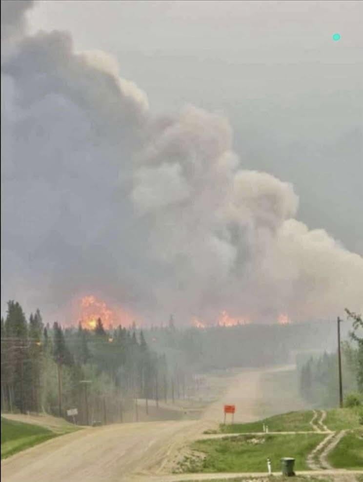
July 1, Canada Day, will be the 158th anniversary of Canada’s founding. However, celebrating this year doesn’t feel apropos, as thousands of Indigenous people and settlers and untold numbers of wildlife are scrambling to survive the fiery flames raging across the country. “Water is life” is the most accurate slogan and solution to the wildfires that continue to blaze across Alberta, British Columbia, and Saskatchewan.
Kailin Aleekuk of Inuvik, Northwest Territories, now lives and works in Edmonton, Alberta. She and her family are thankfully not affected by the fires. “We just experienced the smoke coming through Edmonton...we just keep the kids inside when it's really smoky," she said. Aleekuk and her family follow the Alberta Emergency Alert system and have available 511 Alberta, Smoke Forecast, and the Wildfire Status. She is doing her best and following the news.
On June 11, 2025, it was reported that the smoky air was rated Very High with a 10 to 10-plus. At-risk populations were encouraged to avoid strenuous outdoor activities, while the general population was advised to keep their windows closed and to reschedule outdoor activities. Much needed rain was forecast to arrive later in the week.
We must pray for rain and send the droplets to Western Canada. Children still must attend school until the fourth week of June. Students are not dismissed until June 23 for Albertans, June 25 in Saskatchewan, and June 26 in British Columbia. Less than two weeks away, the days feel long.
Children from First Nations follow the school division’s decisions. The High Prairie School Division in Treaty 8 posts on its website, Wildfire Protocol, where parents and educators have access to its Facebook page (facebook.com/hpsd48), the hpsd.ca website, and can text “Y” to 978338 for SMS messages.
Aleekuk took a photo of the sky on June 10 while she sat in her car. She's grateful she hasn't had to stop working and that she has been able to stay home. "My heart is with those who [evacuated]," she said in a whisper, adding that evacuation orders have been in effect for the Chipewyan Lake, Loon River, Peerless Trout Lake, and Red Earth Creek First Nations since the end of May.
Chipewyan Lake, unincorporated, is in the Municipal District of Opportunity No. 1, with 87 members working and living on its 429.94 hectares. Loon River First Nation in Red Earth Creek, AB has a population of 747 who live and work on the 21,906-hectare reserve. Peerless Trout Lake First Nation of Peerless Lake, AB has 1,061 members working and living on a 3,553-hectare reserve. Red Earth Creek’s municipal district is in Opportunity No. 17 of Alberta with 315 residents on 2,952-hectares. The total of these four displaced First Nations is 2,210 residents on 28,840-hectares, or 111 square miles. That's a lot of land to leave for descendents of generations who have lived, learned, loved, hunted, grown up, and been buried there.
There are 16 Chiefs for the 41 First Nation communities in Treaty 8. These Chiefs have important jobs, even more so in times of community crisis. Chief Andy Alook of Bigstone Cree Nation in Wabasca, AB, speaks on Facebook and reminds folks to stay away from their homelands until deemed safe and the fires are out. It is difficult for evacuees, who are unaccustomed to city life and find themselves bored, unable to ride their four-wheelers or play sports. Plus, there’s overcrowding in the sterile hotels.
British Columbia newspaper, The Penticton Herald, reported that Chief Alook said the community is accepting donations. Buildings have been demolished and need to be rebuilt, and funds are needed across the North.
Norma Dunning (Padlei Inuk) lives and works in Regina, SK, after years in Edmonton. She reports that as many as 15,000 northern residents have been evacuated, mostly First Nations. She said, “Here in Regina, the forest fire smoke blows into the city regularly. It is so thick that highway driving is not recommended. 10 is the highest rating for poor air quality, and we've been having days when the smoke is so thick that the weatherman will say the air quality is an 11 or more, and we are told not to be outside. I truly wish that people would realize the devastation that occurs when home communities that are our cultural centers and where tradition can be practiced—traditional medicines, Sun Dances, and times of community gathering and smudging and praying—are lost as well.”
Dunning added, “I think of these fires as a disaster of the worst kind. Our summers have become [about] surviving forest fire smoke and heat. I feel that summer is harder to live through than winter now…keep in mind that northern people are told not to bring their pets and animals.”
Critical Resources
Saskatchewans can call the toll-free number for the Saskatchewan Wildfire Inquiry Line, 1-855-559-5502, available daily from 8 a.m. to 10 p.m. Regina residents can call (306) 787-8539 between 8 a.m. and 8 p.m. The Saskatchewan Public Safety Agency has its own Information for Evacuees with sections on Evacuation Information, Evacuated Communities, Contact Information, SaskAlert, Emergency and Community Support, and the Provincial Disaster Assistance Program.
SaskAlert has a Sask Evac app for iOS and Android. People can register for alerts in English or French. The Canadian Red Cross and Highway Hotlines are standing by. The Saskatchewan Public Safety Agency has an up-to-date interactive map. The Provincial Disaster Assistance Program guides local authorities, individuals, eligible communities, and more.
The Natural Resources Canada website shows the Canadian Wildland Fire Information System with up-to-date maps of the entire country. Four different maps detail the fire behavior, fire monitoring, mapping and modeling, hotspots, and fire weather. Each map has different colors with blue, green, yellow, orange, red, and gray. We want pale gray and/or blue colors on this fire weather map for Canada and her people to start healing.
The third map on the Natural Resources Canada site shows the hotspots under Fire M3. Aerial footage reports the heat, which reflects red dots to appear across the map of Canada. These dots need to become invisible for Canadians and the land to heal.
The site also contains extensive information that is important for families and friends to know the current facts, whereby they can make informed decisions on when to leave and where to go.
The science, the expertise, the strong firefighters, and the great minds it takes to conquer these wildfires deserve medals from Governor General Mary Simon (Inuk).
We send prayers for the displaced Indigenous people, settlers, wildlife, and the land herself. The damage from these wildfires will take years to mend. But first, the Canadian fires must end.
Ella Nathanael Alkiewicz (Labrador Inuk) is a journalist from Nunatisavut, a member of the North American Indian Center of Boston (NAICOB), and owner of Ella Alk Inuk LLC. She is a featured artist for UnMonument and will show her work in July at NAICOB. She lives on the Nonotuck lands with her family and her cat.
Top photo: Fires in Alberta, photo by Nate Dunning.